What's in a Name?
That which we call a rose by any other name would smell as sweet.
William Shakespeare
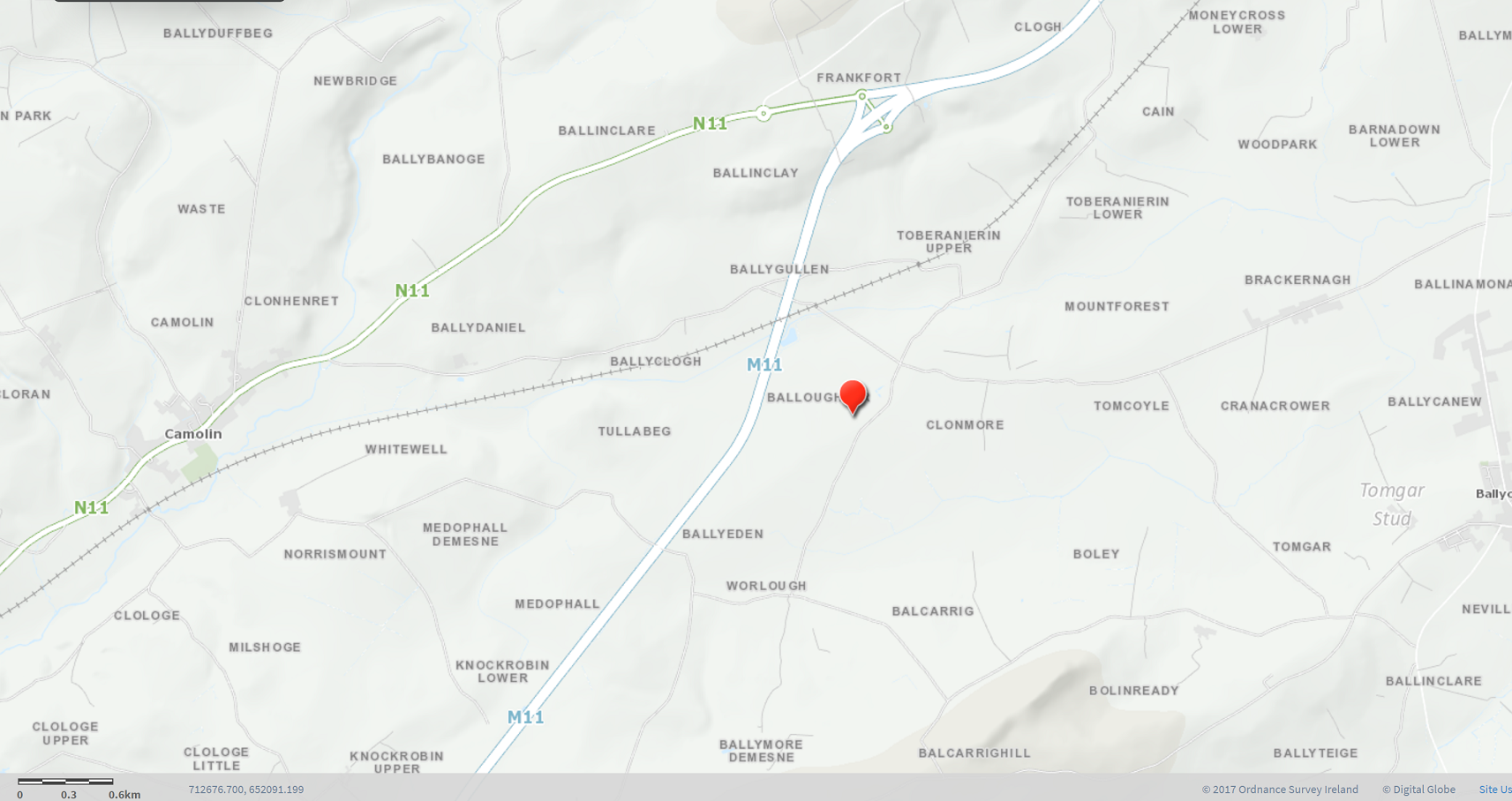
Ballyoughter is a village in the Electoral Division of Balloughter, in the Civil Parish of Toome which is situated in the Barony of Gorey, County of Wexford.
The Irish name for Ballyoughter is Baile Uactar. The official English name of Ballyoughter is Balloughter, and the official Irish name is An Baile Uachtarach (translated as Upper Townland). The townland has been known through the years by different variants such as Ballyoughter (present day), Ballyoughtre (Tithe Books 1823-37), Balloughter (Griffith’s Valuation 1853), Ballioughteragh (Civil Survey in 1654-56).
There are six contiguous townlands to Ballyoughter: Clonmore to the East, Ballygullen to the North, Tullabeg and Ballyclough to the West and Ballyeden and Worlough to the South. The townland of Tubberneering is also very close to its northern border. Worlough which is due south of Ballyoughter and very close to the church and national school is, in fact, in the Electoral Division of Ballymore (Civil Parish of Kilbride).
The Ballyoughter townland has an area of almost 100 hectares or nearly 250 acres. It covers 0.9912 km². In terms of national townland sizes, it ranks 29276th (879th largest in Wexford). It’s coordinates are: 52°36′54″N 6°22′24″W
The Balloughter Electoral Division is home to 25 townlands in total and they are listed below:
Ballinclare, Ballinclay, Ballybanogue, Ballyclough, Ballydaniel, Ballyeden, Ballygullen, Ballyoughter, Clologe, Clologe Little, Clologe Upper, Clonmore, Frankford, Knockrobin Lower, Knockrobin Upper, Medophall, Medophall Demesne, Milshoge, Mountforest, Norrismount, Toberanierin Lower, Toberanierin Upper, Tomcoyle, Tullabeg, Whitewell.
There are at least two other places in Ireland with the same name, one in Ballaghaderreen Electoral Division in Co. Roscommon and the other in Ballycahill Electoral Division in Co. Tipperary.
Names of nearby townlands
Ballyclough is from the Irish “Bealach Cloiche” meaning the stone way/pass. This may refer to the pathway through the townland from Tubberneering to Camolin before there was a road built in the area. The townland has had many variations of its name dating from the earliest on record as Ballaclogh in 1581 to Ballaghcloghe, then Ballaghcleigh before it appears to have settled as Ballaghclogh in the 17th century. In the 18th century it was became Ballyclogh, followed by Ballyclaugh during the 19th century before it reverted to Ballyclogh as it is known today.
Ballyeden is from the Irish “Baile Uí Éidín” meaning the town of the descendants of Éidín (possibly Hayden or similar) or, alternatively, the town on the brow of the hill. It has been recorded in many forms over the centuries but is known today as Ballyeden.
Ballygullen is from the Irish “Baile Ó gCuilinn” meaning O’Gollan’s/Cullen’s Town. It is referenced as far back as 1601 as Ballicollin. In the Civil Survey of Wexford in 1654, it was called Ballyogullen and subsequently dropped the ‘o’ to become Ballygullan through the 18th and 19th century. In more recent times, the spelling has evolved to its current name, Ballygullen.
Clonmore is from the Irish “Cluain Mór” meaning big meadow or pasture. In the Civil Survey of 1654, it was named Cloumoore but has been recorded as Clonmore since the beginning the 18th century.
Tullabeg is from the Irish “An Tulaigh Bheag” which translates as hillock or small hill. It was known as Tullybegg when the landowner was Edward Medop (of MedopHall). In the Civil Survey 1654, it was known as Tullobeg but reverted in the 18th century to Tullybeg before it became known as Tullabeg in the 19th century.
Tubberneering is from the Irish “Tobar an Iarainn” meaning the Iron Well. This is due to the historic chalybeate (Iron Well) located within the townland. It has been spelled in numerous different ways over the centuries and even today there is no one definitive way of spelling the name. Toberanierin or Tubberneering, take your pick.
Worlough is from the Irish “An Fuarlach” meaning swollen or flood in respect of a river or lake. This townland was well known for its wetlands in times gone by before the lands were drained. The townland was first referenced in The Civil Survey of Wexford in 1654 as Forlagh. Over the next few centuries, it has been known by Warlough, Wore-lough and more recently as Worlough.
Neighbouring Townlands of Ballyoughter
Understanding Ireland's Administrative Units
On this website, there are references to government and administrative structures which existed in Ireland from the 12th to the 20th Century. To assist in your understanding the many references on this website to these structures, you will find a brief outline of the most relevant administrative units and their functions below.
The County
In Norman times (12th to 14th Century), the county was administered by a sheriff whose duties included arranging court sessions, collection of taxes, and overseeing Crown properties and lands. The county was the unit for the administration of justice, and the maintenance of courthouses, asylums, roads, and hospitals.
The Barony
The Barony structure of administrative regions was established between 1534 and 1606 and has its origins in the ancient divisions of Ireland when families or ‘septs’ controlled small territories of land. When the Normans arrived, these tribal lands formed the basis for the creation of Baronies. Each County was sub-divided into Baronies and each Barony was sub-divided into Civil Parishes.
The Barony structure was fully complete in 1606 when North Wexford was divided into three Baronies resulting in a final national tally of approximately 267 Baronies. The Barony structure has since become obsolete, ceasing to have an administrative function following the Local Government Act of 1898. However, Baronies remain important when researching records such as land ownership and census taken before 1901 which used the Barony as the basis of collecting data.
The Civil Parish
The Civil Parish is the Catholic Parish as they existed before the Reformation. It is smallest sub-division of the Established Church. Even though they were never formally abolished, they gradually ceased to have an administrative in the 19th century and were replaced by Poor Law Divisions.
Even though the functions of the Civil Parish have ceased, they are still used for certain legal purposes such as to locate deeds of property registered between 1833 and 1946. They were also included on the nineteenth century maps of the Ordnance Survey of Ireland. By 1898 Poor Law Unions had completely replaced Civil Parishes as the basic local government unit.
The Poor Law Union
In the early 19th century, Ireland was a place of widespread poverty. The Irish Poor Laws, a series of Acts of Parliament, were designed to deal with the social problems caused by extreme poverty in Ireland. The Irish Poor Law Act of 1838 followed a similar Act in England in 1834. It resulted in the country being divided into 130 administrative units called Poor Law Unions.
Each Union had a workhouse established in its district and from where poor relief would be administered. Being selected as the market town in the Poor Law Union was a significant matter as the Poor Relief system generated business for local traders who supplied the workhouses.
A Board of ‘Poor Law Guardians’ (who were elected or appointed by local magistrates) administered the affairs of the Union. An additional Poor Law Union was created in 1848 and 32 more were added in 1850 after the Famine bringing the total to 163.
Initially, it was projected that the new system of Unions would cater for approximately 80,000 impoverished people (c.1% of the population). However, by 1851 the Great Famine had driven nearly 300,000 people (c.4% of the population) into workhouses. This number does not include those who received ‘Outdoor Poor Relief’. As time passed, the Poor Law Unions became the centre for administration for many services such as housing, sanitation, and health.
The Local Government Act 1898 resulted in the transfer of housing and sanitation functions from the Poor Law Unions to the newly established District Councils. Poor Law Unions were mostly abolished, and eventually workhouses closed in the south of Ireland in the 1920s. Many workhouses are evident in towns around the country today as district hospitals or county homes. County homes housed a wide range people such as the elderly, unmarried mothers, people with physical, and mental illness as well as adults and children with intellectual disabilities.
District Electoral Divisions
Poor Law Unions led to subdivisions called District Electoral Divisions. These were drawn up by the Poor Law Boundary Commission with the purpose of producing areas of equivalent size and value in terms of rates. The District Electoral Divisions were formed by grouping several Townlands together. An original function was to elect one or more members to a Poor Law Board of Guardians.
District Electoral Divisions ceased to have an electoral purpose and, today, many people will have little or no idea which Electoral Division they live in as they hold little importance compared to that of the Parish community. They continue, however, to be used for rare administrative purposes involving census divisions and for defining Local Electoral Areas/Constituencies even though they may cut across District Electoral Divisions. Outside Dublin, most District Electoral Divisions boundaries have remained unchanged since the mid-19th Century except in the case of rapidly expanding urban population areas.
Dispensary District and Registrar’s District
Following the 1851 Medical Charities Act, Poor Law Unions were divided into Dispensary Districts. A medical officer, paid for by the Union’s poor rates, administered these districts. There were approximately 798 Dispensary Districts in total across the country.
In 1864, when civil registration of deaths, births and marriages was introduced, a Dispensary District was renamed a Registrar’s District. It was a district which was made up of several District Electoral Divisions.
Townlands
The Townland is a small area of land at a local level and is the smallest division of civil administration. It dates from medieval times. There are over 62,000 Townlands in Ireland. Townlands were often subjected to boundary changes or divisions and their sizes ranged from a few acres to several thousand acres. Townlands were used for the setting rents and conducting valuations, surveys, and census. When researching historical information on people, land, property or tax records, knowing the Townland will help with your search.
County Councils, Urban and Rural Councils
The Local Government (Ireland) Act 1898 established a structure comprising County Councils, Urban and Rural District Councils. District Electoral Divisions combined to elect members to County Councils. Rural District Councils were abolished everywhere by 1930 through the passing of Government Acts.
Commission inquiring into the number and boundaries of Poor Law unions and electoral divisions, 1849 Twelfth report - Gorey Union Extract
From this report from 1849, 11 years after the Poor Law Act of 1838, you will note that there were still proposed changes to the Electoral Divisions in Gorey Poor Law Union. The townlands listed in this 12th report match those that exist today. The only notable difference is the presence of two ‘Clonmores’. The explanation for the existence of two like named townland is explained in The Past/Historical Land Surveys/Tithe Applotments 1823-38.
Courtesy of University of Southampton/JSTOR as per the Community Collection terms and conditions.
Selection of Candidates for the Balloughter ED on 15th February 1899
Due to the clarity and quality of the source print, you may need to download the file and read it using the ‘zoom’ feature in Adobe.
Newspaper images are reproduced with the kind permission of Wexford County Council Library Archives.